Places to visit
on Lake Garda
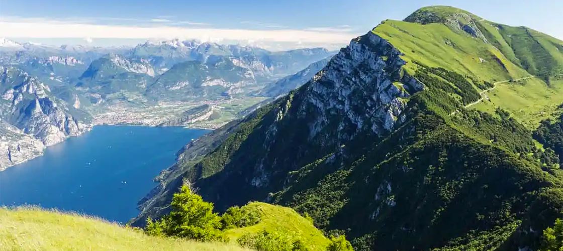
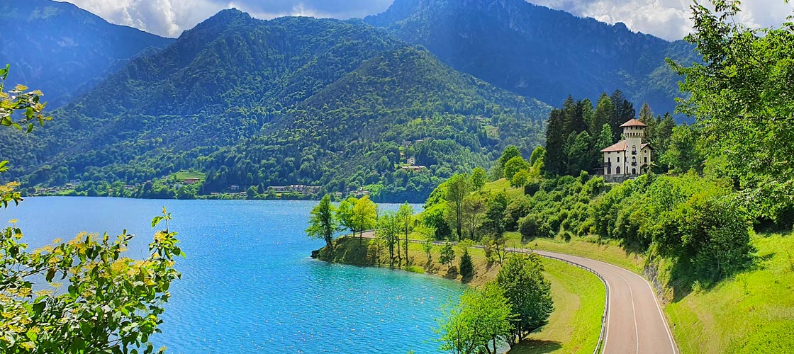
Monte Baldo
Monte Baldo is a mountain massif with a height varying from 65 meters, at the level of Lake Garda, to 2218 meters at Cima Valdritta, its highest peak, it is included between the provinces of Trento and Verona and separates two large valleys , modeled by the Quaternary glaciers, gave rise to Lake Garda and the Val d’Adige.
The group is divided into the Baldo ridge, culminating at Punta Telegrafo (2199 m) and Monte Altissimo di Nago (2070 m).
On the western side it descends quite steeply towards Lake Garda, interrupted only by the narrow plateaus of Prada, San Zeno and Albisano.
In the southern part there is a large basin between the Baldo ridge and the steep slopes of the Val d’Adige, between Novezzina and Spiazzi, forming the beautiful grassy plateau where Ferrara di Monte Baldo is located.
To the south, where the Garda and Adige valleys extend and almost touch, the Baldo slopes down towards the hilly basin of Caprino Veronese.
Monte Baldo is also called “the garden of Europe” for its great floristic heritage.
Some species of flora and fauna survived the glaciations as they were above the level of the glaciers, like an island in the middle of the sea, while in other areas they have completely disappeared. Thus were born the so-called endemic species of Baldo that can be admired in the Botanical Garden of Monte Baldo in Novezzina.
Thanks to the very varied morphological characteristics, the Baldo has different climatic zones, ranging from the Mediterranean belt to the montane, boreal and finally alpine belt. Each of these bands has diversified vegetation.
Thus we can find in the Mediterranean the presence of olive trees, vines, citrus fruits, holm oaks, hop hornbeam, manna ash and downy oak and, a little higher up, chestnut and oat trees, as well as species with low trunks such as orchids, capers, rosemary, lantana, laurel, primrose, lavender, broom and many others.
While at 1000 metres, in the mountain belt, we find beech, linden, silver fir and larch, in the boreal belt above 1800 meters there are mountain pines, alpine junipers and heather. In this belt we find also some very important blooms: in addition to the white crocus and the gentian, the endemic Sedge and Anemone del Baldo and the rare Pianella della Madonna.
In the last strip, the Alpine one, the vegetation is rocky, characterized by the potentilla, the raponzolo, the rhododendron and the presence of the rare herb Caglio del Monte Baldo.
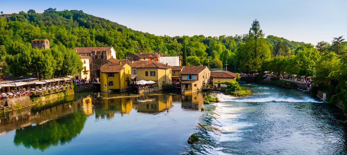
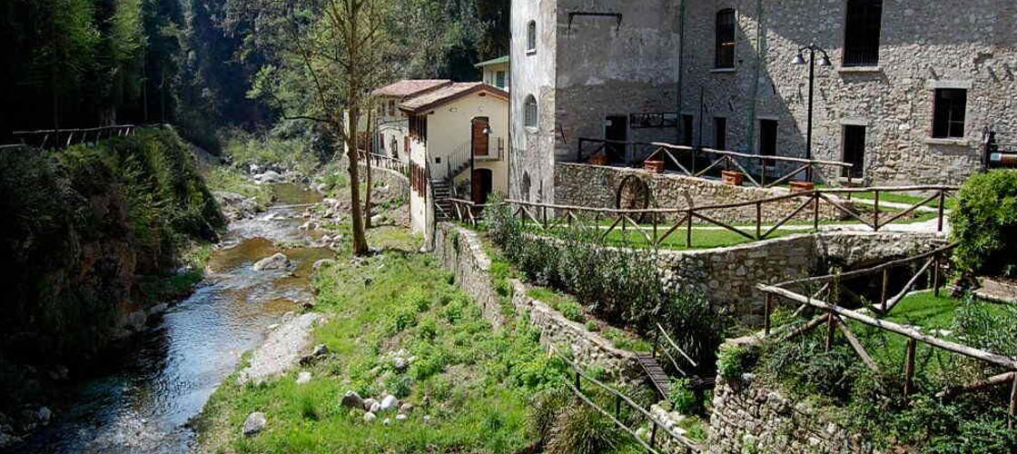
Borghetto di Valeggio sul Mincio
Borghetto is famous for its enchanting mills and for the mighty remains of the Ponte Visconteo over the Mincio river.
The Ponte Visconteo was built in 1393 at the behest of Gian Galeazzo Visconti and was connected to the Scaliger Castle above it by two high crenellated curtains and integrated into a fortified complex that extended for about 16 km.
From the top of the hill, the Castle continues to dominate the Mincio Valley with its towers: the Tonda Tower remains of its oldest part, a particular construction that dates back to the 12th century, while the rest of the complex dates back to the 14th century. . Inside the village, above the remains of the Romanesque church dedicated to Santa Maria of the century. XI was built the church of San Marco Evangelista in neoclassical style.
The history of Borghetto, whose name means “fortified settlement”, is closely linked to the point in which it is located: in fact, since ancient times, it has been built in the easiest point for fording the river Mincio.
The position is therefore an important and strategic crossing point and a border area between the lands of Mantua and those of Verona. In this frontier area the Gonzaga, the Scaligeri, the Visconti, the Serenissima Republic of Venice and, more recently, Austria and France have followed one another.
Borghetto offers a suggestive landscape, surrounded by nature and in perfect symbiosis with the river. A small village of a few houses, immersed in the waters of the Mincio which opens up here and is channeled into various branches which convey the water towards the large blades of the ancient mills, recently transformed into small reception centers for tourists.
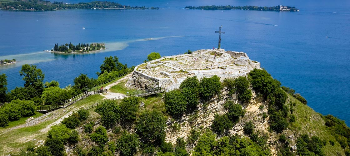
Rocca di Garda
The Rocca di Garda had a great reputation for being impregnable and of such importance that it gave its name to the entire Benacus basin, replacing the ancient Latin name of the lake with the modern one of Germanic origin.
From a geological point of view, the Rocca di Garda is a mountain that emerged from the sea in the Miocene period and was later shaped by the grip of the Garda glacier. Its slopes are heavily wooded, covered by the typical Mediterranean vegetation, while on the top there are secular oaks and chestnut trees.
From the archaeological finds found, the human presence on the Rocca dates back to the Bronze and Iron Ages. Fortified in the Lombard era, the Rocca is famous for having been in the 10th century. the dungeon of Queen Adelaide of Burgundy.
From the archaeological excavations carried out on the Rocca, some walls were found which give us an idea of what the ancient castle must have been like; a large building, with a rectangular plan, almost overhanging the lake.
The surviving foundations, dating back to the early Middle Ages, have demonstrated the long residential use of the entire area and its use as a burial place.
Near the Rocca, in 1663 the Hermitage of the Camaldolese Benedictine Monks was built around the church of San Giorgio, a cloistered monastery, of which only a few internal courtyards and the small church can be visited.
The church preserves an interesting altarpiece of San Giorgio slaying the dragon: behind the building there are the friars’ cells and the guesthouse, a stupendous viewpoint over the Gulf of Garda and a small friars’ cemetery.
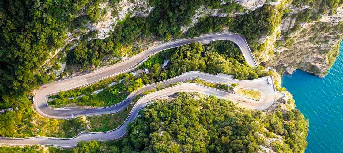
Strada della Forra
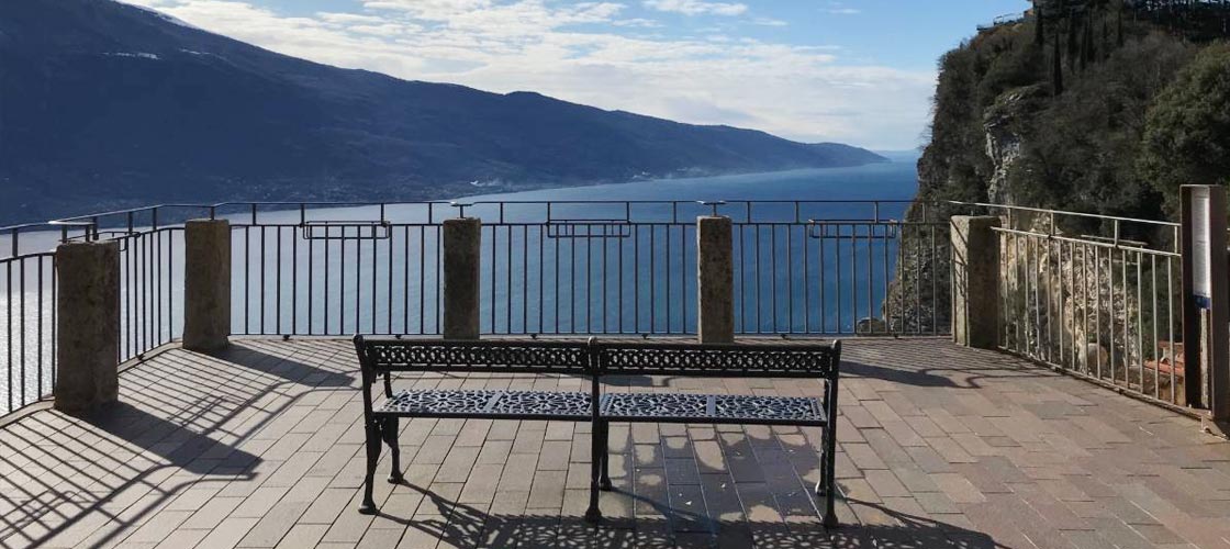
Tremosine is also called the “Terrace of the Lake” as it is located on a lively plateau overlooking the western shore of Lake Garda.
To get to Tremosine, take a road along the deep gorge of the Brasa stream, at times carved into the rock and at times overhanging overhangs.
For many centuries until the early twentieth century, the Tremosine plateau was connected to the shore of the lake, 300 meters below, only by an impervious and very steep path.
Strada della ForraOnly in 1913, on the initiative of the village parish priest, was the road built which from the port goes up to the hamlet of Pieve and from here reaches Vesio. After four years of strenuous manual work and mines, the “Strada della Forra” was born and at the time, the national press gave it much prominence and called it “the most beautiful road in the world”.
Inside the gorge is the effigy of the Madonna, proclaimed the “patroness of Tremosine motorists” in 1960.
Nestled in the bowels of the mountain, along the crack dug by the Brasa torrent, the road is serpentine with a truly unique view of the lake, a suggestive route that fascinates with its rocks, tunnels, gorges and glimpses of the landscape.
Ledro Valley
Valle di Ledro is a pre-Alpine valley of glacial origin, located in south-western Trentino, at about 650 meters above sea level: it is connected to the west with the Valle del Chiese and to the east with Lake Garda.
The Ponale stream that runs through it originates from Lake Ledro in the middle of the valley and ends in Lake Garda with a 30-metre waterfall.
Green is the dominant color of the Valley: green in the most authentic sense due to the extension of the woods that cover 70% of the total area and green of the vast meadows that follow the forests towards the high altitudes.
The human presence in Valle di Ledro since prehistoric times is evidenced by the pile-dwelling settlement found in the lake which recently became part of the UNESCO heritage and which constitutes one of the most important attractions of the place.
The origin of Lake Ledro is due to a dam of morainic origin dating back to the fourth ice age.
In addition to the pile-dwelling village, other attractions can be found in the small villages of the valley.
At the entrance to the valley, Molina owes the origin of its name to the mills which, together with sawmills, ironworks and nail factories, thrived in the area in the past and where you can still visit the old forges that produce hand-beaten nails.
After passing the villages of Tiarno di Sotto and di Sopra, it is possible to reach the nearby biotope of the small Ampola lake, a protected oasis of great naturalistic interest and which leads to the discovery of marvelous aquatic and marsh plants.
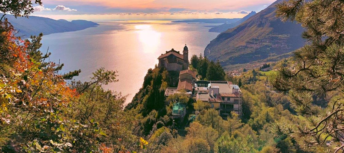
Sanctuary of Montecastello
The Sanctuary of Montecastello stands on a limestone outcrop at an altitude of 700 meters, overlooking Lake Garda.
It is located in Tignale, a village located almost entirely on a plateau, immersed in the greenery of the olive trees, overlooking the lake, but which also has a small extension to the lake, called “Prà de la Fam”, where there is also the “limonaia” ” namesake.
It is one of the last lemon houses on the lake still in operation and dates back to the 17th century. This lemon greenhouse is an example of the particular architectural structures present on Lake Garda, especially in the Western Riviera, which served to protect the many citrus crops existing at the time from any harsh winters.
The Sanctuary of Montecastello is one of the most important places of worship not only in Tignale but also in the whole of Lake Garda.
Its privileged position offers the visitor unique and spectacular panoramas ranging from the high peaks of Monte Baldo to the Sirmione peninsula. Recently restored, it is very popular not only with pilgrims but also with those who love its architectural, artistic and scenic beauty.
Built on the ruins of an old temple, later transformed into a castle, the Sanctuary at the entrance has two nineteenth-century buildings which are now used as reception facilities for pilgrims, then there is a loggia and from here there is the access stairway to the church , on two ramps, which dates back to 1599.
The Sanctuary is also called the Sanctuary of the Madonna della Stella thanks to the miraculous appearance of a “star” which put an end to a bloody battle that took place in Tignale in 1200.
Valley of the paper mills of Toscolano
The Valle delle Cartiere di Toscolano has been a paper pole of great importance since the fifteenth century.
The wealth of water coming from the Toscolano river which flows along the valley and the right climate, have made the place suitable for the construction of numerous paper mills, the first of which was already functioning in 1381, and for the start of an intense production activity and paper trade.
Even important printers moved from Venice to the shores of the lake to be closer to their best suppliers.
In the long period of activity in the plants, talented paper manufacturers such as the Delays, the Veroneses, the Hells, the Emmers, the Bianchi-Maffizzolis and the Donzellis have alternated.
As many as 61 paper mills joined each other along the banks of the river, thus creating one of the largest and most important poles in Italy.
At the beginning of the 20th century, the paper industry in the Valley began to decline, as with the advent of new technologies, electricity replaced water as the driving force and consequently paper production was transferred to the shores of the lake where the connections are smoother and more comfortable and where it still continues.
Furthermore, other factors, such as strong competition and the collapse in the price of paper, led to a gradual depopulation of the Valley and the definitive cessation of the industrial activity linked to paper in the 1960s.
The current landscape of the Valle delle Cartiere di Toscolano is very suggestive and characterized by thick vegetation, by the remains of the paper mills surrounded by greenery and by ravines, in some cases very deep, carved by the watercourse of the Toscolano river which, for example, between the localities of Garde and Quattroruote, it flows between two very high rock faces.
The remains of the factories, the traces of the canals that conveyed the water necessary for production, the road, at times dug into the rock, built by the paper-making entrepreneurs themselves, blend with the luxuriant vegetation which, over time, has reappropriated the spaces left empty from industry after the end of paper production and the slow abandonment of the Valley.
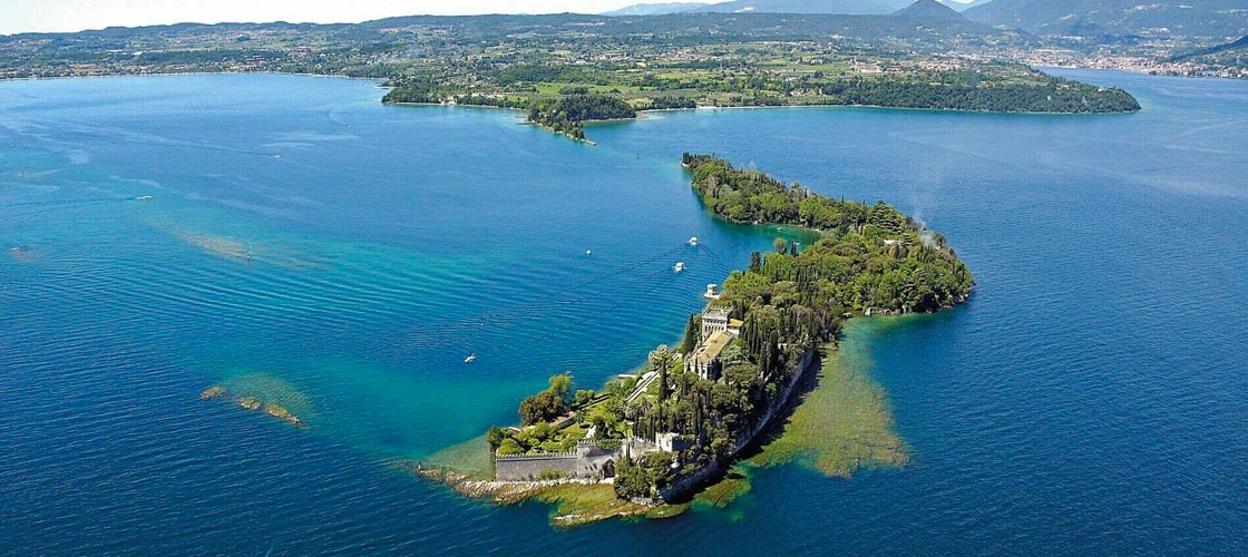
Garda Island
The island of Garda is located on the Brescia side of Lake Garda in the municipality of San Felice del Benaco. It is approx. 200 meters from the promontory of Capo San Fermo, it is approximately one kilometer long and is on average 600 meters wide.
The island was already inhabited in Roman times.
Around 1220 we know that St. Francis visited many places in northern Italy, including Lake Garda, and on this tranquil island he built a simple hermitage for the friars.
In 1429 the old monastery of Isola del Garda was renovated and enlarged and the island became an important ecclesiastical and meditation center.
In 1797 the monastery was definitively suppressed by Napoleon who became the owner of the island.
Subsequently, Isola del Garda became state property and in the following years it had various owners who arranged the villa and contributed to the creation of the park, building retaining walls towards the lake and importing fertile land and exotic plants. The palace was enriched by terraces arranged in an Italian garden with rare plants and unique flowers.
Between 1890 and 1903 the old villa was rebuilt and became the current grand palace in Venetian neo-Gothic style designed by the architect Rovelli.
Today the villa is owned by the Borghese Cavazza family who continue to take care of the park and the building they inhabit with passion and which, by reservation, open to the public with guided tours from April to October.
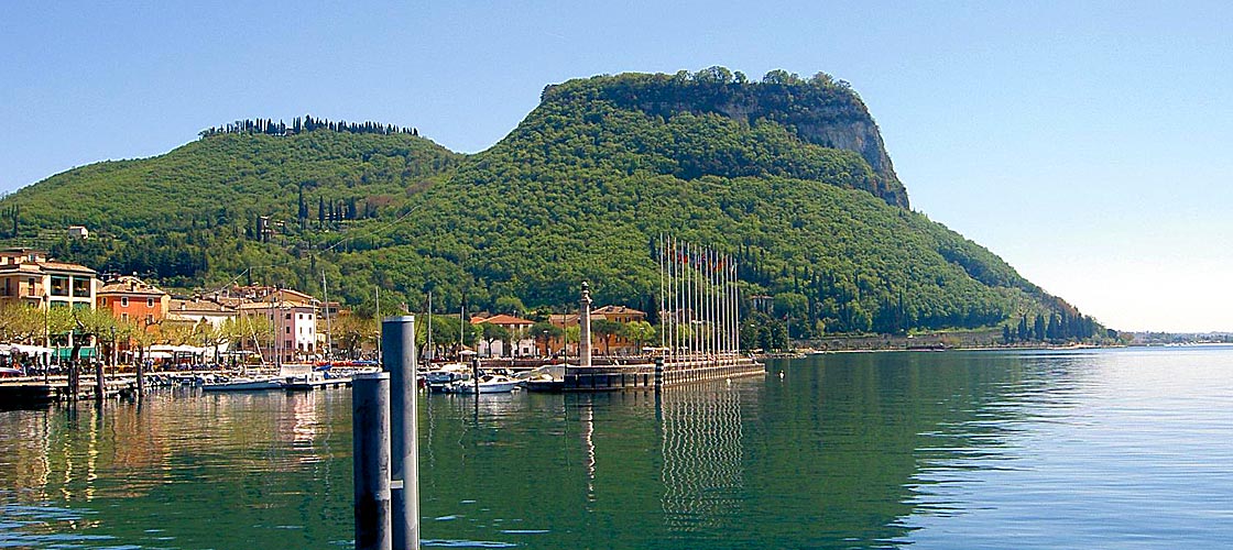
Rocca di Manerba
The Rocca di Manerba is located on a rocky outcrop overlooking Lake Garda, on the Brescia side.
On the top, in a spectacular position, are the remains of the ancient medieval castle known as the “Rocca”, surmounted by a large cross: three circuits of defense walls dating back to the 12th-13th century are visible.
All this is inserted in a protected green area of about 90 hectares called the Rocca di Manerba Natural Park, a true paradise for lovers of trekking and birdwatching.
The park is characterized by a great variety of plant species, including autochthonous, Mediterranean plants and botanical rarities, such as splendid wild orchids: in a relatively small space, many plants that belong to different climates coexist thanks to the presence of the lake.
We recommend a visit to the Museo della Rocca, which also houses the Archaeological Museum of Valtenesi.
Rocca di Manerba In the naturalistic section, the tree and fauna species that inhabit the Park can be admired through splendid photographs; in the archaeological section, on the other hand, the historical phases of the site are retraced from the Copper Age to the Middle Ages, through the observation of the finds from the archaeological excavations of the Rocca, the Riparo Valtenesi, the stilt house of San Sivino and the Pieve di S. Maria.
Mincio Park
The protected area of the Mincio Park was established by the Lombardy Region in 1984 and includes the territory of the 13 Lombard municipalities located along the Mincio river.
The municipalities of Mantua, Ponti sul Mincio, Monzambano, Volta Mantovana, Goito, Marmirolo, Porto Mantovano, Rodigo, Curtatone, Borgo Virgilio, Bagnolo San Vito, Roncoferraro and Sustinente are part of it.
Parco del MincioThe Mincio Park extends over a vast area formed by the river Mincio which leaves Lake Garda at Peschiera del Garda (Verona), enters the territory of Mantua at Ponti sul Mincio crossing the rolling morainic hills of Garda and passing between many small fortified villages and then continues in the Po Valley until it reaches the great river Po in Sacchetta di Sustinente.
The Mincio Park includes various Reserves and Natural Sites of excellence and offers a thousand ideas for visits starting from the Mincio Valleys, an important wetland, to river excursions in the lower Mincio, organized with departures from Mantua, Grazie di Curtatone and Rivalta sul Mincio, observing the storks’ nests in the Bertone wood-garden, paddling among the reeds and cycling along the several tens of kilometers of cycle/pedestrian paths that cross the Park or that flank the Mincio from Peschiera to Mantua.
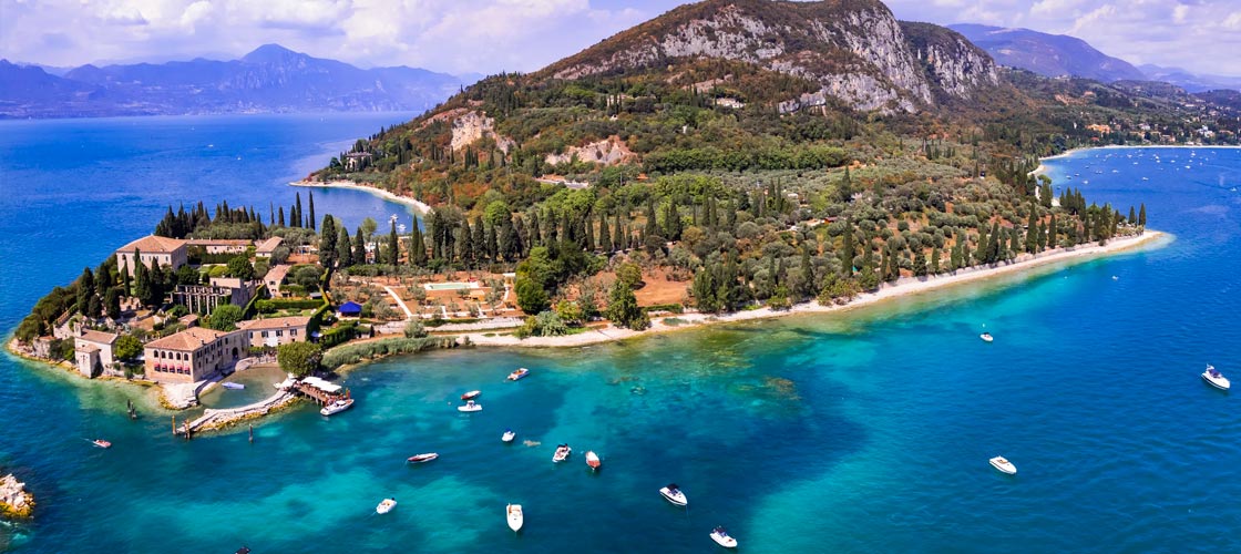
Punta San Vigilio
Punta San Vigilio juts out into the lake, very green with cypresses and centuries-old olive trees and is one of the most romantic places on Lake Garda.
It has been inhabited since Roman times and the origin of its name seems to refer to the Holy Monk Vigilius who lived here in the 17th century. IV doing his utmost to convert the people of the lake to Christianity, or, according to a legend, to the satyr Vigilius who, loving the nymph Stella unloved, blinded by anger, transformed her into the rock emerging from the waters in front of the peninsula which still today bears her first name.
At the tip is the beautiful Villa Guarienti, built in the mid-16th century to a design by Michele Sanmicheli, a famous Venetian architect.
The villa, privately owned, is surrounded by a garden of Renaissance geometries and next to it is the small church of San Vigilio, of more ancient origins than the villa.
Walking along a cobbled street, we find the small port overlooked by the Locanda San Vigilio, one of the most exclusive hotels on Lake Garda.
On the north side of the peninsula we find the Baia delle Sirene, a beautiful gulf framed by the greenery of cypresses and olive trees with an equipped beach and all the services to fully enjoy the hot summer days.
Behind this small peninsula is Monte Luppia, famous for its prehistoric “rock carvings”: over 3,000 cataloged images representing men, weapons, animals and various symbols.
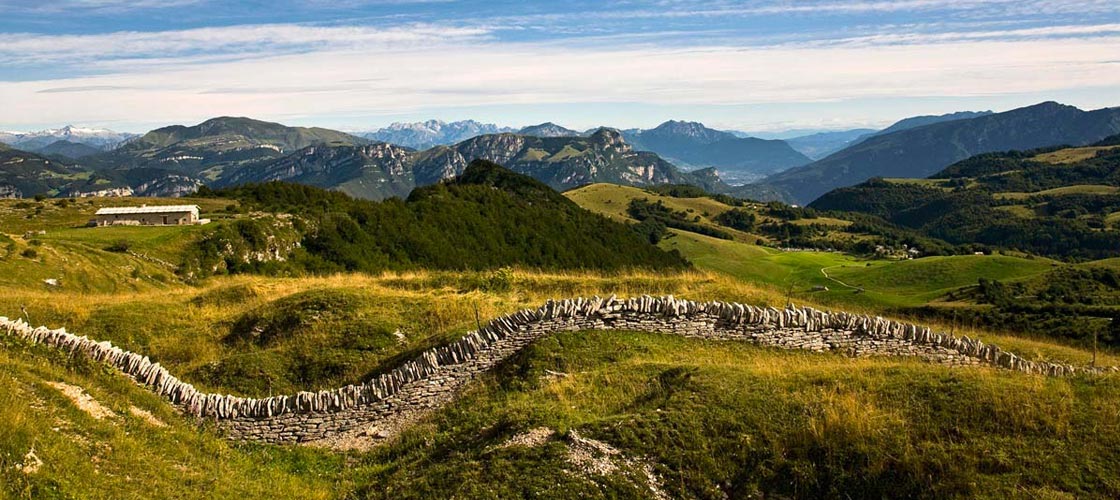
Lessinia Natural Park
The Lessinia Natural Park, established in 1990, occupies 10,000 hectares of the summit part of the Lessini Mountains, between the provinces of Verona and Vicenza.
The Lessinia Natural Park aims to enhance and preserve this territory rich in history, archeology, unique naturalistic and geological aspects, as well as to protect the ethnic, cultural and linguistic heritage of the “Cimbre” populations.
The Lessina Natural Park is a vast plateau of woods and pastures where nature and the traditions of ancient populations merge: a land of spectacular karst phenomena and characteristic districts with typical stone roofs, rich fossil deposits unique in the world, testifying to its origin .
Famous are the fossil deposits of Bolca-Pesciara and Monte Postale, which have provided finds of plant and animal species of lagoon and oceanic environments.
Over 50 million years ago in the area of the Lessinia Natural Park, instead of Bolca and all of Lessinia, there was a warm sea, rich in tropical fauna and flora. Tens of thousands of fossils, fish and plants from the Tertiary Era have been extracted from Pesciara di Bolca and can now be admired in the local Fossil Museum.
Terrazza del Brivido
The Terrazza del Brivido is located in Tremosine, another peculiarity of this area overlooking the lake.
It is a real terrace, suspended 350 meters above the lake, from which you can enjoy a panorama that takes your breath away, even for those who do not suffer from vertigo.
If the day is clear and the sun is shining, the show is unique, romantic and scary at the same time, given the overhang on which the terrace is built.